5
Mar
2018
Teesdale Way – Piercebridge to Blackwell Bridge
Filed under: Teesdale WayDistance: 13 miles
Map: OS Explorer 304 – Darlington & Richmond
Start: Piercebridge (GR NZ 211159)
Click to View Start Position on Google Maps
The village of Piercebridge goes back a long way and is worth a look around before starting the walk. In fact the bulk of the village is contained within the walls of the Roman Fort known as Vinovium. There are some attractive cottages about but the church of St Mary is relatively new being built in 1873 in Victorian times. The name of Piercebridge changed slightly over the years and is derived from an old word for osiers (willow plants) which were no doubt used on the bridge over the River Tees, which flows through the south of the village. Vinovium was constructed between AD 260 and 270 and served to guard the crossing of the Tees on Dere Street also known as Watling Street (sections of which are used in several of my walks). A cursory glance of the map shows this road heading in a straight line on both sides of the river downstream of the current bridge and indeed the Romans had been on site for two centuries prior to the building of the fort that we see today. In around 1771 the remains of the old Roman bridge were swept away by the floods that devastated the Tees, Wear and Tyne with very few bridges surviving in the area.
Much of the fort lies under the village green and the houses, but fortunately the north east corner has been excavated and can be visited free of charge, just behind St Marys Church (which is a much favoured name for churches hereabouts as all those on the Four Churches walk from Barningham illustrate).
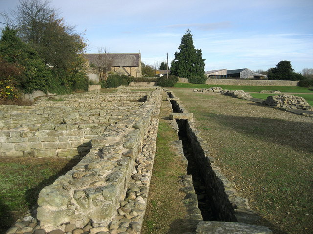
Piercebridge Roman Fort
Photograph by Chris Heaton / CC BY-SA 2.0
We leave the fort and head towards the Tees down a lane behind the houses to reach the river. This is followed downstream to emerge onto the A67 at Carlbury Mill which was a corn mill. We now proceed east to High Coniscliffe passing the Duke of Wellington pub. Just before the church of St Edwin we leave the road to return to the river. The church of St Edwin is from the Early English period but the site goes back to Norman times as the north doorway and and the window at the west end of the nave on the south side show.
Our route now follows a delightful three mile section of the Teesdale Way alongside the Tees. There are several places here where the erosion has left sandy areas where there are sand martins nests and twice over the last few years these have been the first spring sightings of these attractive birds. The route passes under the A1M to arrive at Low Coniscliffe passing behind some gardens onto a minor road and then crossing two fields to arrive at the Baydale Beck Inn which has a beer garden and makes a good lunch stop.
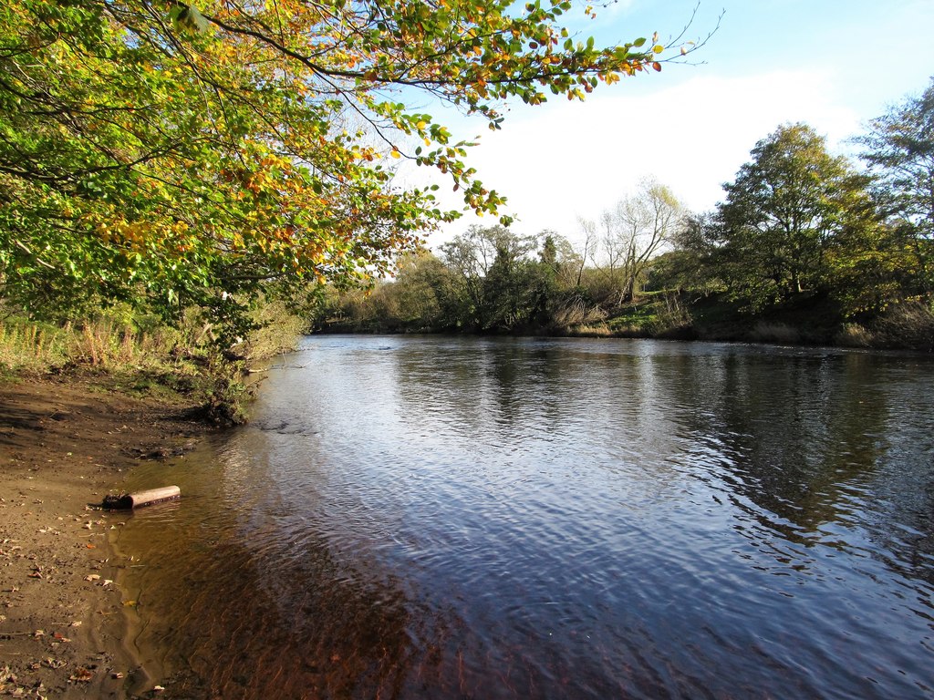
The Tees near Low Coniscliffe
Photograph by Gordon Hatton / CC BY-SA 2.0
There is now a short section of road walking on the A67 which is nevertheless interesting as you are passing Broken Scar Waterworks owned by Northumbria Water which was formerly Darlington Corporation Waterworks dating back to the mid 1800s. Some of this is now listed as a historical monument and there are open days where a steam powered beam engine dating back to 1903 can be seen working. Another one to see is the Ryhope Pumping Station near Sunderland – check their websites for open days, one of which is normally Sept/ Oct.
Immediately after passing the waterworks and at a picnic site return to the riverside for another section of fine walking, with good birdlife, of about one and a half miles where at a bend in the river you cross into a wood and after a short climb reach Blackwell village, which is a suburb of Darlington. There are two places of interest here. Firstly after passing Baydale Farm you will note a ruin in the field to the east of the farm. This is the remains of a leper hospital from the 14th Century.
At the start of the climb up to the road at Blackwell you will notice a wooded hill covered in trees marked on the OS map as a castle. There was a wooden castle here but the site was originally an Iron Age fortification. Here you turn right to reach the A66. The Teesdale Way divides into two sections to Croft and we take the one to the west which is to me the better route to Croft. We follow the A66 to the roundabout and then take the road on the left to Stapleton. Prior to the construction of the A1M this was the A1 through Barton to Scotch Corner. At Stapleton we leave the Teesdale Way near to the Bridge Inn named after the old bridge.
Stapleton is an old village going back to the 9th Century. The Lord of the Manor Miles de Stapleton was killed at Bannockburn in 1314 and in the same century the bridge here was swept away to be replaced by a ferry. There is now a section of one mile of quiet road walking back under the A66M to Cleasby village. Most of the land around here is on a bed of limestone overlaid by some clay and much good quality gravel which has been exploited over the years. The remnants of one of the sites at Cleasby has been well restored and is a haven for birds as well as a centre for fishing.
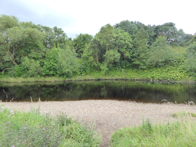
River Tees near Cleasby
Photograph by Oliver Dixon / CC BY-SA 2.0
At Cleasby village take the lane at the west end of the Green back to the riverside and follow the path upriver under the A1M upstream to a big bend at Manfield Scar (GR 233135) where the path leaves the Tees and continues on higher ground passing to the south of Glebe Farm and crossing Manfield Beck close to the Tees. The path now leads to Holme House and then reaches Dere Street which is followed back to Piercebridge.
On the way it passes the George Hotel which was a Coaching hotel in former days and has a very interesting story associated with it. For those born before 1960 many will recall a song called “My Grandfather Clock” written way back in 1876 which tells the story of a clock which stopped, never to go again when the old man died. The story goes that this event took place here at the George Hotel when the landlord Christopher Charge died. Takes some believing but that is the story and the writer Henry Clay Work an American did visit the George Hotel. It has been recorded by Johnny Cash, Sam Cooke and Burl Ives. The one we used to hear was by The Radio Revellers on Children’s Favourites.
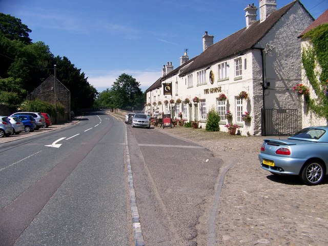
George Hotel
Photograph by Elliott Simpson / CC BY-SA 2.0
After 13 miles you are entitled to have refreshments as the Carlbury Inn in Piercebridge is nearby, as is the Crown at Manfield village which are both recommended but check the opening times.